The overwater acoustic profiling method is a seismic geophysical technique which is useful for sub-bottom sediment layering identification, depth to bedrock determination and sub-bottom hazard studies.
The method consists of towing an energy source appropriate for the depth of investigation and bottom materials behind a survey vessel along a traverse line. The acoustic signal reflected from the sub-bottom is received by a towed hydrophone array and amplified and digitally recorded as a continuous profile. In the field, the data are visually reviewed in real time on the high resolution display of a notebook computer.
Energy sources range from high frequency systems suitable for detailing the thickness of a few metres of soft organic material in a fresh water lake environment, to powerful boomers or airgun arrays where deeper sub-bottom penetration is required.
Overwater positioning is accomplished using a high resolution GPS system in realtime or post-processing differential dynamic mode. Bathymetry information is recorded synchronous with the positioning and seismic information using a narrow beam fathometer.
Large areas can be covered quickly and economically, resulting in the classification of materials and detailed information on the sedimentary layers above rock.
Interpretation of the data employs the SMT 2d/3dPAK which accepts the overwater seismic profiling data in SEGY format together with positioning, bathymetry and other information. The package provides rapid section and plan seismic reflection interpretation with complete horizon tie management in a fully integrated workstation environment. Products include sections, detailed horizon contour maps and layer isopachs.
Used in conjunction with overwater seismic refraction surveys the approach allows classification of sediment and bedrock types based on their acoustic velocities. Higher velocity materials correspond to more competent sediments.
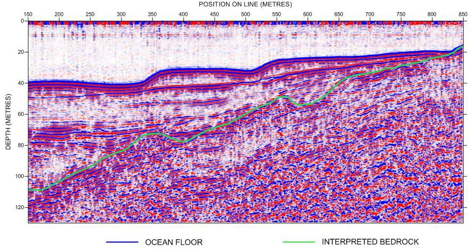
Applications include the use of overwater profiling surveys to provide detailed subsurface information in support of geotechnical engineering work for harbour facilities. This may be as simple as determining that sufficient sediment is available above bedrock for pile driving, or may be employed to provide detailed subsurface mapping, which together with barge drilling, furnish the critical geotechnical information for berth facilities foundations, caissons, etc.
Pre-dredge surveys may be carried out, together with bathymetric surveys, to identify hazards such as shallow bedrock, and to classify the sediment types. This information determines how much volume is to be removed by dredge operations, and allows appropriate deployment of suction versus clamshell dredging. Post-dredge bathymetry completes the project by verifying dredge contract fulfillment, and that the depth meets all navigation requirements. Other applications include: